LIHU‘E — A report released earlier this month and obtained last week by The Garden Island shows vivid details of the storm that hit the islands in March, causing floods, landslides and road closures and prompting disaster declarations from local,
LIHU‘E — A report released earlier this month and obtained last week by The Garden Island shows vivid details of the storm that hit the islands in March, causing floods, landslides and road closures and prompting disaster declarations from local, state and federal governments.
In early March, an unsettled atmospheric pattern over the central North Pacific intensified and produced damaging severe weather and significant flooding across several islands that will be remembered for quite some time, according to Kevin Kodama, senior service hydrologist at the National Oceanic and Atmospheric Administration/National Weather Service Weather Forecast Office in Honolulu.
In a report prepared April 5, Kodama states the islands were hit by two weather systems between March 2 and March 9.
O‘ahu was the first island to be affected by an upper-level trough coupled with a slow-moving cold front on the evening of March 2, causing 7 inches to 11 inches of rainfall over Ko‘olau Mountains, the report states.
“The focus of significant weather shifted to Kaua‘i on the afternoon of March 3 as the initial pulses of heavy rain began to impact the eastern two-thirds of the island,” Kodama said. “At 4 p.m. HST, the Hanalei gauge registered what would be 76 hours of continuous rainfall at this site.”
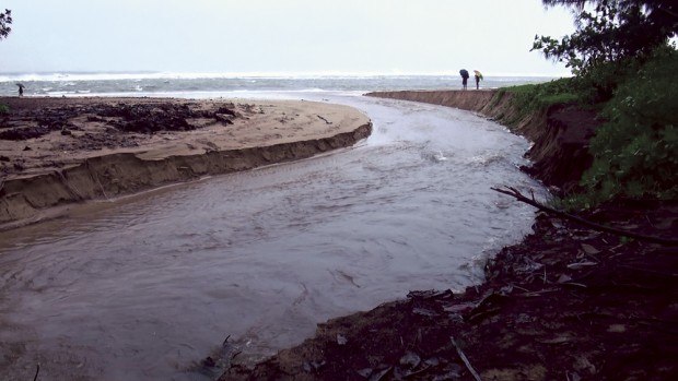
A few hours after the rains started, Hanalei Bridge was closed. Multiple spikes in Hanalei River’s flow kept the highway inundated and isolated Hanalei Town for almost three days, according to the report.
Meanwhile, flash flooding caused numerous road closures in other areas of Kaua‘i, the report states, including Kapa‘a, Ha‘ena, Kalihiwai, Wailua and Koloa.
Between 8 a.m. on March 3 and 2 p.m. on March 6, total rainfall on Kaua‘i ranged from 10 to 25 inches over the east-facing slopes to more than 35 inches on the north-facing slopes, according to Kodama.
As Kaua‘i continued to be pounded by the storm, rainfall hit O‘ahu again on March 5, causing streams to overflow and highways to close. A thunderstorm over eastern O‘ahu dropped hail as large as 1.5 inches, the report states.
On the evening of March 6, the first weather system that hit Kaua‘i and O‘ahu eased. But the bad weather was far from over.
“The atmosphere did not provide much time for recovery,” Kodama states in the report. “In the early morning hours of March 8, an approaching upper-level low-pressure system began to destabilize the air mass again over the island chain.”
This time Big Island, Maui and Molokai were also hit.
Thunderstorms developed over North Maui County, and heavy rains fell over the windward slopes of Haleakala and the eastern half of Molokai, causing flash floods and road closures there, the report states.
Later that day, a strong thunderstorm hit near Kamuela on the Big Island, causing minor flooding and dropping 1-inch hail.
“The weather event peaked in the early morning hours of March 9, when strong thunderstorms fired up on the windward slopes of Maui, Molokai, O‘ahu and Kaua‘i,” said Kodama, adding that a severe thunderstorm over east Maui dropped 1.75-inch hail.
In Honomaele, on eastern Maui, a recording gauge measured 12.6 inches of rain in six hours, from 10:45 p.m. on March 8 to 4:45 a.m. on March 9, including 6.3 inches in a one-hour period, between 12:45 a.m. and 1:45 a.m., according to the report.
“This is believed to be the highest officially measured one-hour rainfall total since the Dec. 14, 1991, Anahola, Kaua‘i, flash flood (maximum one-hour rainfall of 6.7 inches),” Kodama said.
On Kaua‘i, right before midnight on March 9, heavy rainfall flared up near Hanalei and then evolved into a large area encompassing the northeastern region of the island, the report states.
“Coming so soon after nearly 3 feet of rain, runoff occurred hard and fast, resulting in a rise of Hanalei River’s water level of 6 feet within 90 minutes,” Kodama states.
As a result, Hanalei Bridge was once again closed and remained closed all day. Flash flooding caused the closure of several roads in Kilauea, Kalihiwai and Wailua, and damaged Kapahi Bridge in Kapa‘a.
Dime-size hail was reported in Kapa‘a, and at least one window was reported broken by hail, according to the report.
Logs from the Kaua‘i Civil Defense Agency show the storm’s development on March 9.
A flash flood warning was issued in the early hours of March 9 Civil Defense staff members reported to the county Emergency Operations Center in Lihu‘e. The warning was initially to last until 3:45 a.m., but the county did not lift the warning until 11 p.m.
Meanwhile, continual communications ensued between Civil Defense, police and fire departments, county Public Works staff, the National Weather Service, county Parks and Recreation staff, Transportation Security Administration, state Department of Transportation, county Transportation Agency, Department of Defense and staff member at the mayor’s office.
The gauge at Hanalei River rose steadily and at 3:10 a.m. peaked at 12 feet, 3 inches. Flooding and landslides occurred all over the island.
Communications logged from the National Weather Service to Civil Defense indicates a strange occurrence at Ka Loko Dam at 3:35 a.m.
“Ka Loko Dam has been steadily rising around 21 to 22 feet. Sudden drop to under 5 feet,” the log states.
There is no other mention of Ka Loko Dam in the Civil Defense logs after that.
Down the slopes where the dam is, Kuhio Highway had been severely damaged by the storm’s development in the vicinity of Mile Marker 22.5 in Kilauea.
Workers built an emergency bypass, diverting northbound traffic to Kolo Road and southbound traffic to Pili Road.
At 11:19 p.m. the county issued a press release announcing the National Weather Service canceled the flash flood warning for Kaua‘i as of 11 p.m.