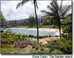
A new bridge over the Wailua River may be in the works for a planned bicycle/pedestrian path. All three alternate routes for a controversial portion of the planned Nawiliwili-to-Anahola path call for small bridges to be built over the river
A new bridge over the Wailua River may be in the works for a planned bicycle/pedestrian path.
All three alternate routes for a controversial portion of the planned Nawiliwili-to-Anahola path call for small bridges to be built over the river for the bikers and walkers.
Three alternate routes have been submitted for public comment by a Honolulu consultant for the two-mile bicycle/pedestrian pathway proposed to run from Lydgate Park to Waika‘ea Canal in Kapa‘a.
One route includes a beach-side track along the north end of Wailua Bay that has provoked public opposition.
Condominium owners who live along the stretch of the bay affected have voiced concerns that a pathway built on coastline property located immediately makai of them and owned by Kaua‘i County could intrude on their privacy and spoil resting places for endangered Hawaiian monk seals.
A draft environmental assessment done by Kimura International, the O‘ahu-based consultant for the county, noted no final alignment has been decided at this time.
The two-mile segment proposed from Lydgate Park to the Waika’ea Canal in Kapa‘a is the topic of discussion at a third public meeting on the bike/run path. The meeting is scheduled at the Kapa‘a Middle School cafeteria from 7 to 9 p.m. on Thursday, July 1. The meeting is sponsored by the county Department of Public Works.
The segment is part of a 16-mile, six-phase, bicycle-pedestrian pathway county officials have proposed along the coastline from Nawiliwili Harbor to Anahola.
If and when completed, the third project will link up with two other phases that help make up the larger project.
The entire project, which has been advocated by Mayor Bryan J. Baptiste’s administration, is expected to significantly enhance recreational opportunities for the Lihu‘e and Kawaihau districts. The two districts make up the most densely populated areas on the island.
As a way for bicyclists and walkers to gain access to the third phase, the consultant recommended two ways for people to cross the Wailua River.
The consultant suggested constructing a small, cantilevered bicycle/pedestrian bridge off the makai side of an existing cane-haul bridge which sits parallel to the main bridge that carries Kuhio Highway over the Wailua River.
The other option would be to build a second, small bridge that would run parallel to the makai side of the same cane-haul bridge. The bridge is overseen by the state Department of Transportation Highways Division.
Regarding the three alternate pedestrian/bicycle pathways, the consultant suggested:
- The first pathway run northward on the county-owned shoreline located makai of the former Seashell Restaurant by Wailua Bay. As the pathway heads northward, it would run past eight condominium projects and hotels between the restaurant and the Kauai Coast Resort at the Beachboy. Some residents at the condominium projects contend such a pathway would be intrusive to them. The pathway would continue along shoreline areas around the Kapaa Missionary Church and Village Manor, make its way to Niulani Street, which county leaders could acquire for the project, run along Moanakai Road, and end at the Waika‘ea Canal;
- A second option would have the pathway run mauka of the old Seashell Restaurant and along Papaloa Road, to areas around the Kauai Sands Hotel and then back on Aleka Loop. The pathway then would run to Ala Road and Niulani Street and onto Moanakai Road before ending at the Waika‘ea Canal;
- A third option would have the pathway run mauka along Kuamo‘o Road to a drainage canal located on the mauka side of the old Coco Palms Hotel in Wailua. The pathway would then intersect Hale‘ilio Road mauka of the Kuhio Highway intersection, with signs to be erected to warn drivers of a “mid-block crossing,” the environmental study noted. The pathway would then pass through private property mauka of the Wailua Family Restaurant and Wailua Shopping Center, and continue on an abandoned cane-haul road on land now owned by the Midler Family Trust. A mid-block crossing would be set up in the same area that could bring bicyclists or pedestrians southbound on Papaloa Road and to the Kinipopo Shopping Village. Other parts of the pathway are proposed to run northward and parallel to Kuhio Highway and around the mauka side of the Kauai Shopping Village and Waipouli Plaza. The third alternate route would take users onto Panihi Road in Kapa‘a to an inland juncture of the Waika‘ea Canal and northward to the baseyard operated by the Kaua‘i Island Utility Cooperative.
The tail end of the most northern leg of the trail would take users onto Kololoku Road and to the Waika‘ea Canal.
Other parts of the third phase call for feeder roads that would run past Wailua Houselots Park and to the Nounou Mountain trailhead.
A final part of the proposal calls for a path connecting the Kawaihau Road bicycle-pedestrian path to the Kapa‘a-Kealia bicycle/pedestrian path.
The third phase would link up with two other phases of the proposed six-phase, 16-mile pedestrian/bicycle project.
The first phase involved the construction of a 2.3-mile bicycle/pedestrian pathway, including amenities, at Lydgate Park. The work has been completed.
The second phase calls for a 4.3-mile pathway to run from Waika‘ea Canal to Ahihi Point in the northern part of Kealia.
County officials are considering proposals that were submitted for the “design-build phase” of the project, the consultant said.
Construction of the project is anticipated to start in the summer of 2005, the consultant said.
The other parts of the proposed 16-mile project include:
- A fourth phase that would run from Ahukini to Lydgate Park, a distance of four miles;
- A fifth phase would run from Nawiliwili Harbor to Ahukini, a distance of eight miles that would also take pathway users to Lihu‘e town and back to the Nawiliwili area;
- A sixth phase that would run from Kuna Bay to Anahola, a distance of three miles.
The entire six-phase project is to be developed at a cost of $30 million, mostly federal funds.
The public comment period for the study runs through Thursday, July 8.
Written comments on the draft environmental study for the two-mile pathway from Lydgate Park to Waika‘ea Canal can be sent to Doug Haigh, DPW, 4444 Rice St., Suite 175, Lihu‘e, HI 96766, or to Glenn Kimura, Kimura International, Inc. 1600 Kapi‘olani Blvd., Suite 1610, Honolulu, HI 96814.
Lester Chang, staff writer, may be reached at 245-3681 (ext. 225) or mailto:lchang @pulitzer.net.