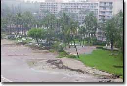
The heavy downpours early Saturday morning were too much for Keona’awanui Stream near where it dumps into Nawiliwili Bay. The stream usually remains underground of the Kaua’i Marriott Resort and Beach Club before dumping into the bay via a concrete
The heavy downpours early Saturday morning were too much for Keona’awanui Stream near where it dumps into Nawiliwili Bay. The stream usually remains underground of the Kaua’i Marriott Resort and Beach Club before dumping into the bay via a concrete culvert near Duke’s Canoe Club.
“Last night she (Keona’awanui Stream) decided to follow her old course… it’s a disaster down there,” said Don Heacock, district aquatic biologist for the Department of Land and Natural Resources. “There are lawn chairs out in the ocean, bungalows collapsing and there are coconut trees down.”
Calls to Kaua’i Marriott management were not returned Saturday, but from various eyewitness accounts, the stream broke out of its concrete channel sometime early that same day. “Last night there was so much rain and urban runoff and water will take the shortest path to the sea,” said Heacock.
The shortest path for the stream was through the eastern portion of the Marriott property — the stream’s historic bed before the hotel was developed. “The stream ran through the parking lot two to three feet deep and tore up tiles and filled the pool with mud,” Heacock said.
Unconfirmed reports state there were evacuations of some hotel guests. The Marriott would not confirm whether any evacuations had occurred.
Elsewhere on the island, roads and bridges were reopened as many prepared for a couple days break from the downpours. Hanalei Bridge had been closed overnight Thursday and part of Friday, but was reopened later on Friday. The Kekaha area reported some damage from high water.
Forecasters say this will be a short-lived break from the weather pattern that has been delivering punishing showers to the Garden Island. “The radar looks fairly dry for Sunday,” said Gregory Hall, officer in charge for the National Weather Service Kaua’i. “The tradewinds have returned, but the atmosphere is still fairly unstable.”
That will all change late tonight into tomorrow morning. “We’re calling for another wet round of showers moving in the start of the new work week late Sunday night, continuing through midweek,” said Honolulu National Weather Service forecaster Henry Lau on Saturday.
“With the ground as wet as it is we’ll be back under flash flood warnings and watches by Monday,” said Hall, with the Kaua’i weather service.
Lau said there will be two upper level disturbances moving in late Sunday through Tuesday. “The one Tuesday will be more significantly widespread.” he said.
The system late Sunday will be a “wet tradewind” and by late day Monday the winds will shift to a south/southeasterly direction in advance of the approaching Tuesday system, said Hall.
“Tuesday there will probably be about two to four inches, and that’s on the conservative side,” said Lau.
“It will be equal in intensity to what we experienced over the last couple days,” Hall said on Saturday.
He said, later in the week, after Wednesday, the tradewinds will move back in and there should be a drier period with a more stable atmosphere.
Both Lau and Hall said that these types of systems and rainfall are typical for this time of year. “As we move closer to spring we catch the tail-ends of these central Pacific cold fronts and they hold together as fronts over us,” Hall said.
The organized nature of a front will bring the increased rainfall versus a tradewind pattern.
“This was a minor rain,” said Heacock. “This was about a five to 10 year average flood.”
Beaches near river and stream mouths were clogged with debris Saturday, and water immediately adjacent to the shore has turned a chocolate-brown color in many areas. Officials with DLNR say the conditions are conducive to shark encounters (see page A10) and leptospirosis outbreaks from the muddy contaminated water.
“There are about 25 ‘no swimming’ signs on Kalapaki Beach,” Heacock said.