After four tourists drowned in a harrowing week last month, the Kaua‘i County Council yesterday buoyed the public dialogue on ocean safety by making a policy statement about the risks and responsibilities associated with certain North Shore attractions. The seven-member
After four tourists drowned in a harrowing week last month, the Kaua‘i County Council yesterday buoyed the public dialogue on ocean safety by making a policy statement about the risks and responsibilities associated with certain North Shore attractions.
The seven-member legislative body unanimously passed a resolution that urges government agencies and guidebook authors to participate in a concerted effort to address the hazardous conditions at Queen’s Bath and the path leading to the natural tide pool carved into a lava shelf at the base of a cliff in Princeville.
“Queen’s Bath is indeed a gorgeous spot when it’s calm, but it’s a death trap at least 200 days a year,” said Dr. Monty Downs, a water safety advocate.
The morning session discussion at the Historic County Building emanated from the deaths of two visitors — sisters-in-law Tonya Cataldo, 39, of Parker, Colo., and Heather Westphal, 33, of Washington, D.C. — who were walking along a ledge Oct. 12 at Queen’s Bath when a large wave swept them out to sea.
Witnesses, water safety experts and the Kaua‘i Visitors Bureau offered potential solutions and identified the steps being taken to keep visitors and residents safe from such deceptive disasters.
Increased signage, guardrails, an emergency phone, an informational kiosk, temporary closures, revised guidebooks and a broad educational campaign were proposed.
The resolution specifically urges the county engineer to consider closing the county parking lot and easement path leading to the Queen’s Bath coastline between the rainy, winter months of October through April for routine maintenance.
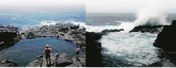
Queen’s Bath is reached from a trail that starts at a parking lot in Princeville. It is steep and often slippery, following a narrow stream through lush vegetation and passing by a picturesque falls along the route. The rugged coastline, which is controlled by the state Department of Land and Natural Resources, must then be navigated some 150 yards horizontally to arrive at Queen’s Bath.
Councilman Mel Rapozo indicated his support for seasonal closures of the parking lot and path easement, but water safety experts said closing the access on a day-by-day basis by “people who know what they are doing” would be a smarter move.
Lifeguard instructor John Tyler Cragg, who supported increased signage and a solar-powered emergency call box among other measures, said closing the trail seems “a little extreme at this point.”
Patrick Durkin, a former lifeguard who now runs Aquatic Safety Management, said a seasonal closure fails to address core drowning prevention strategies. These include lifeguards, warning signs and education, “an area we haven’t put enough into.”
He said lifeguards are a proven frontline of defense. But it was noted that the four recent drownings occurred at unguarded areas.
Warning signs, such as “Dangerous Shorebreak” or “Strong Rip Current,” are “a litigation avoidance mechanism,” Durkin said.
Others agreed that signage was important, but its impact negligible.
Signs show “a huge wave, a little man and a rock,” Rapozo said. “Show some photos of some dead bodies. Let the tourists see that … if the goal is to prevent drownings.”
“Signage is a feel good measure,” said Kekaha resident Bruce Pleas, an avid surfer and ocean weatherman. “People will hang towels on the signs.”
Signs are posted at the Queen’s Bath trailhead warning of the dangerous conditions.
Aside from signage, Durkin said the county needs to “out the guidebook.”
The resolution says Queen’s Bath is frequented “mainly by tourists who read about the destination in tourist guidebooks such as ‘The Ultimate Kaua‘i Guidebook.’”
It also says “the descriptions of Queen’s Bath in the guidebooks do not provide sufficient information as to its dangerous nature and instead depicts it as an off-the-beaten-path paradise experience showing pictures of the area during calm conditions.”
The water safety experts, council members and Kaua‘i Visitors Bureau Executive Director Sue Kanoho cast much blame on guidebooks, which they said fail to provide clear warnings of the dangers associated with a place.
Kanoho said the guidebooks should show pictures of Queen’s Bath when it becomes “like a washing machine” in addition to how it appears on a calm day.
Andrew Doughty, author of the popular “The Ultimate Kaua‘i Guidebook,” said yesterday that the current edition, published last month, has taken a stronger stance on Queen’s Bath.
The description in the book’s 7th edition states: “During winter months (generally October–April), high surf often assaults the area. Even when the ocean appears calm, it’s always possible for a rogue wave to snap at this part of the shoreline, knocking people around, maybe even dragging them back into the open ocean. That’s why winter surf typically makes Queen’s Bath unusable.”
“We feel so strongly about ocean safety that we have one of the largest beach safety sections of any guidebook on the market, dedicating over 1.5 pages to the dangers that exist on Kaua‘i and what to watch our for at all beaches,” Doughty said. “This is in addition to individual beach warnings strewn throughout the book.”
He noted that Queen’s Bath is listed in virtually every guidebook, free publications, Web sites and was featured in some of the Hawai‘i Visitor’s Bureau’s literature.
“This has to be a joint effort,” said Kanoho, who has written to a dozen guidebooks asking for their help. “We can’t do it by ourselves.”
Rapozo noted the DLNR’s absence from the meeting. He and others who testified said the state needs to be more involved in the solution.
The resolution urges the DLNR to “consider placing appropriate signage at the termination point of the county path easement leading to the coastline which effectively informs the public of the dangerous conditions.”
Downs said signs fail to provide a “particularly good disincentive.”
Yesterday was an example of a “beautiful but deadly” day, he said, noting a rapidly building north swell that could quickly transform the calm seas.
Councilman Daryl Kaneshiro suggested indicating the number of people who have drowned at the site to make signage more effective.
Downs said “underground signmakers” put up such a sign at Hanakapi‘ai Beach where people had routinely died. He said the Polish visitor who drowned there last month was the first since the sign was posted five years ago.
“Everyone thinks it doesn’t apply to them,” Kanoho said.
Mark McKamey, the North District supervisor for the county’s Ocean Safety Bureau, underscored education.
For instance, all the saves he has made near Queen’s Bath have happened when the near-drowning victims swam with the current away from the coastline. JetSkis from Hanalei can reach the area within five to 10 minutes, he added.
“This is our problem … the island’s, the visitor industry’s, everyone,” said Kilauea resident Christopher Waite, a medic who witnessed the recent drownings at Queen’s Bath. “It’s a vision that stays with you a long time. … It’s not just unsuspecting visitors who are at risk.”
Mayor Bill “Kaipo” Asing’s administration is expected to make a presentation on ocean safety at an upcoming council meeting.
For ocean safety information and current conditions, visit www.kauaiexplorer.com
• Nathan Eagle, staff writer, can be reached at 245-3681 (ext. 224) or neagle@kauaipubco.com