Wailua research part of Archaeology Week By LESTER CHANG – TGI Staff Writer Kaua’i schoolchildren and state officials got a glimpse of old Hawai’i in Wailua Friday. More than 30 students from Kaua’i Christian Academy, the Kapa’a Elementary School and
Wailua research part of Archaeology Week
By LESTER CHANG – TGI Staff Writer
Kaua’i schoolchildren and state officials got a glimpse of old Hawai’i in Wailua Friday.
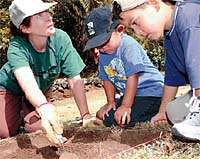
More than 30 students from Kaua’i Christian Academy, the Kapa’a Elementary School and Island School joined Martha Yent, a state Department of Land and Natural Resources archaeologist, and Maria Orr, an archaeologist with the Society for Hawaiian Archaeology, in excavation work at the Holoholoku, or refuge, at Wailua River State Park.
The recovery of shark and pig teeth, coral and glass from two small “test units” left some students in awe.
Ron Dougherty O’Brien, a fourth-grader at Kapa’a Elementary, said the discovery fueled thoughts of becoming an archaeologist.
He thought “Wow” when finding the artifacts, he said.
The excavation was part of Hawai’i Archaeology Week, which was celebrated April 21-29 to heighten awareness of the protection of Hawaii’s cultural resources.
Begun in1985, the event takes people on lectures, field trips, exhibits and excavations throughout the state.
For the Wailua dig, Orr said her main goal was to find aged charcoal by the foundation of a rock wall that rings the refuge off Kuamo’o Road.
Along with information on the genealogy of Kauai’s royalty, radiocarbon-dating charcoal will help illustrate the development and use of the area by ancient Hawaiians, Orr said.
“It is a piece of the pie, and we need more pieces to see what happened here,” Orr said. The charcoal would suggest Hawaiian leaders – either the kupuna (the elders) or ali’i – ordered the burning of trees to clear the area for the benefit of a Hawaiian settlement in Wailua.
Wailua is significant because it was where the important ali’i of Kaua’i lived, said David Helela, president of Na Kahu Hikina A Ka La, a Kaua’i-based Hawaiian organization that serves as caretaker for four of seven sacred sites in Wailua through an agreement with the state.
The group takes care of Hikina’akala heiau, Malae heiau, the Holoholoku refuge, in which can be found the Kalaeokamanu heiau and the Pohakuho ‘ohanau (royal birthstones) and Poli’ahu heiau. The other three sacred sites are Kukui heiau, Ka’awako heiau and Pihanakalani.
Prior to contact with the western world, the ali’i of Kaua’i, his priest and others visited each site during the Makahiki, a time of peace celebrated by Hawaiians from October to January each year during ancient times. They paid tribute to the Hawaiians gods of Lono and Kane, Helela said.
The abundance of fresh water and fertile agricultural terraces along the north and south forks of the Wailua River and the Opaeka’a Stream made the Wailua ahupua’a (the land from the ocean to the mountain) ideal for settlement by Hawaiians, said Randy Wichman, chairman of the Kaua’i County Historic Preservation Review Commission.
Taro fields, fish ponds, sweet potato patches along the coast and marine resources in Wailua Bay provided for subsistence living. The surrounding areas provided, wood, feathers, plants and medicine and materials for kapa-making.
Because the area also provided protection against invasion, Hawaiian royalty made Wailua a political and economic center.
According to legend, Debra Kapule, former wife of King Kaumuali’i, the last king of Kaua’i, moved from Waimea to Wailua in 1835 and was said to have converted the Malae heiau to a cattle den and Kalaeokamanu heiau to a pig pen.
Kapule is said to have made the conversion to demonstrate her break with traditional religion and her embrace of Christianity.
During the 1848 Mahele, marking a massive land division in Hawai’i, Kapule and her son, Isoia Kaumuali’i, claimed land in the lower regions of Wailua, including the Holoholoku, where Kapule had a housesite, Yent said.
Four villages existed in the area:
– Makaukue Village consisted of three pahale, or houselots, on the southern bank of the mouth of the Wailua River, near the Malae heiau.
– Wailua Village, on the mountain side of the fishponds on the northern side of the river mouth.
– Kapuaiomolohua Village, on the ocean side of the fishponds north of the river mouth.
– Kahakoa Village, situated between the river bank and what is now Kuamo’o Road. The village had the largest concentration housesites, with nine claimants.
By the late 1800s, many Hawaiians left Wailua and most of the taro fields were converted for rice cultivation by Chinese farmers. Sheep, cattle and horses were raised in the valley and uplands. The land above the Wailua River valley was planted in sugar cane.
In the 1920s, a railroad was built from Anahola to Hanama’ulu to transport sugar, workers and freight to Lihu’e.
Wailua River State Park was initiated with the Fern Grotto in 1954, and the Poli’ahu area was added to the state park in 1962.
Coco Palms Hotel was built in the 1960s.
Staff writer Lester Chang can be reached at 245-3681 (ext. 225) and mailto:lchang@pulitzer.net